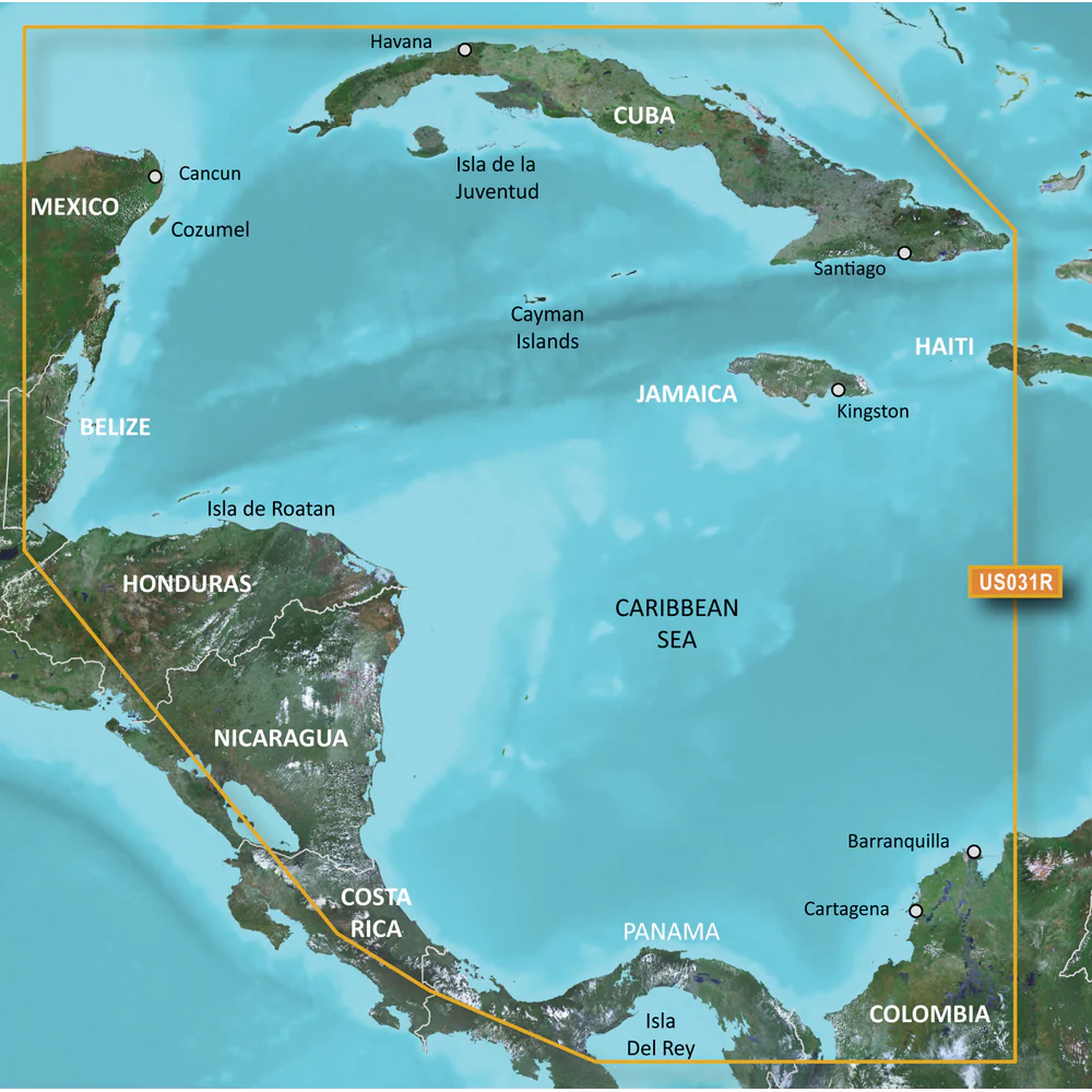
Garmin BlueChart g3 Vision HD - VUS031R - Southwest Caribbean - microSD/SD
Enhance your maritime adventures with the BlueChart® g3 Vision® HD VUS031R, offering comprehensive coverage of the Southwest Caribbean region. Designed for both recreational and professional boaters, this top-tier navigation chart ensures accurate and detailed information to navigate with confidence from Cancun, Mexico to Barranquilla, Colombia.
Comprehensive Coverage
BlueChart® g3 Vision® HD delivers extensive coverage of the Caribbean coast of Central America, including key destinations and navigational hotspots:
- Cancun, Mexico
- Barranquilla, Colombia
- Cuba
- Jamaica
- The Cayman Islands
- Cozumel
- San Andres and Providencia
- Lake Izabal and the Rio Dulce
- The entire Panama Canal and northern Gulf of Panama
Premier Coastal Navigation Charts
Experience unparalleled clarity and detail with BlueChart® g3 Vision® HD's premier coastal navigation charts:
- Industry-Leading Coverage: Updated charts featuring integrated Garmin and Navionics® data for precise navigation.
- Auto Guidance¹ Technology: Automatically calculates routes based on your desired depth and overhead clearance, providing a suggested path to follow.
- High-Resolution Relief Shading: Combines color and shadow to deliver a clearer view of bottom structures compared to contour lines alone.
- Depth Range Shading: Supports up to 10 depth ranges, allowing quick identification of target depths.
- Detailed 1’ Contours: Offers more precise bottom structure representation, enhancing fishing charts and navigation in complex waterways like swamps, canals, and marinas.
Advanced Features
Auto Guidance Technology
The Auto Guidance feature¹ utilizes your specified depth and clearance preferences to calculate the optimal route, presenting a suggested path for seamless navigation.
High-Resolution Relief Shading
Our high-resolution relief shading integrates color and shadow to provide an intuitive and clearer depiction of the seabed compared to traditional contour lines.
1’ Contours
Featuring contours as close as 1 foot apart, BlueChart® g3 Vision® HD ensures an accurate portrayal of bottom structures, greatly benefiting fishing activities and navigation through tight or intricate waterways.
NOAA Raster Cartography
For those who prefer a traditional paper chart aesthetic, NOAA raster cartography2 is available for free download via the ActiveCaptain® app, enhancing your navigation experience.
Depth Range Shading
This feature offers up to 10 different depth ranges, making it effortless to visualize your desired depth levels at a glance.
Shallow Water Shading
Use shallow water shading to mark and avoid areas with depths that are too low, ensuring safer navigation in shallow regions.
High-Resolution Satellite Imagery
Access detailed satellite images of ports, marinas, bridges, and other navigational landmarks, providing superior situational awareness on your journeys.
Unique 3-D Views
Enhance your navigational perspective with MarinerEye and FishEye views, offering additional angles both above and below the water line for improved decision-making.
¹Auto Guidance is intended for planning purposes only and does not replace safe navigation practices.
²Raster cartography cannot be viewed on echoMAP CHIRP and ECHOMAP Plus combos but is accessible on mobile devices via the ActiveCaptain mobile app.
 WARNING: This product may expose you to chemicals known to the State of California to cause cancer, birth defects, or other reproductive harm. For more information, visit P65Warnings.ca.gov.
Important Notice: This product may not be returned to the original point of purchase. Please contact the manufacturer directly with any issues or concerns.
Enhance your maritime adventures with the BlueChart® g3 Vision® HD VUS031R, offering comprehensive coverage of the Southwest Caribbean region. Designed for both recreational and professional boaters, this top-tier navigation chart ensures accurate and detailed information to navigate with confidence from Cancun, Mexico to Barranquilla, Colombia.
Comprehensive Coverage
BlueChart® g3 Vision® HD delivers extensive coverage of the Caribbean coast of Central America, including key destinations and navigational hotspots:
- Cancun, Mexico
- Barranquilla, Colombia
- Cuba
- Jamaica
- The Cayman Islands
- Cozumel
- San Andres and Providencia
- Lake Izabal and the Rio Dulce
- The entire Panama Canal and northern Gulf of Panama
Premier Coastal Navigation Charts
Experience unparalleled clarity and detail with BlueChart® g3 Vision® HD's premier coastal navigation charts:
- Industry-Leading Coverage: Updated charts featuring integrated Garmin and Navionics® data for precise navigation.
- Auto Guidance¹ Technology: Automatically calculates routes based on your desired depth and overhead clearance, providing a suggested path to follow.
- High-Resolution Relief Shading: Combines color and shadow to deliver a clearer view of bottom structures compared to contour lines alone.
- Depth Range Shading: Supports up to 10 depth ranges, allowing quick identification of target depths.
- Detailed 1’ Contours: Offers more precise bottom structure representation, enhancing fishing charts and navigation in complex waterways like swamps, canals, and marinas.
Advanced Features
Auto Guidance Technology
The Auto Guidance feature¹ utilizes your specified depth and clearance preferences to calculate the optimal route, presenting a suggested path for seamless navigation.
High-Resolution Relief Shading
Our high-resolution relief shading integrates color and shadow to provide an intuitive and clearer depiction of the seabed compared to traditional contour lines.
1’ Contours
Featuring contours as close as 1 foot apart, BlueChart® g3 Vision® HD ensures an accurate portrayal of bottom structures, greatly benefiting fishing activities and navigation through tight or intricate waterways.
NOAA Raster Cartography
For those who prefer a traditional paper chart aesthetic, NOAA raster cartography2 is available for free download via the ActiveCaptain® app, enhancing your navigation experience.
Depth Range Shading
This feature offers up to 10 different depth ranges, making it effortless to visualize your desired depth levels at a glance.
Shallow Water Shading
Use shallow water shading to mark and avoid areas with depths that are too low, ensuring safer navigation in shallow regions.
High-Resolution Satellite Imagery
Access detailed satellite images of ports, marinas, bridges, and other navigational landmarks, providing superior situational awareness on your journeys.
Unique 3-D Views
Enhance your navigational perspective with MarinerEye and FishEye views, offering additional angles both above and below the water line for improved decision-making.
¹Auto Guidance is intended for planning purposes only and does not replace safe navigation practices.
²Raster cartography cannot be viewed on echoMAP CHIRP and ECHOMAP Plus combos but is accessible on mobile devices via the ActiveCaptain mobile app.
WARNING: This product may expose you to chemicals known to the State of California to cause cancer, birth defects, or other reproductive harm. For more information, visit P65Warnings.ca.gov.
Important Notice: This product may not be returned to the original point of purchase. Please contact the manufacturer directly with any issues or concerns.
Original: $349.99
-70%$349.99
$105.00Description
Enhance your maritime adventures with the BlueChart® g3 Vision® HD VUS031R, offering comprehensive coverage of the Southwest Caribbean region. Designed for both recreational and professional boaters, this top-tier navigation chart ensures accurate and detailed information to navigate with confidence from Cancun, Mexico to Barranquilla, Colombia.
Comprehensive Coverage
BlueChart® g3 Vision® HD delivers extensive coverage of the Caribbean coast of Central America, including key destinations and navigational hotspots:
- Cancun, Mexico
- Barranquilla, Colombia
- Cuba
- Jamaica
- The Cayman Islands
- Cozumel
- San Andres and Providencia
- Lake Izabal and the Rio Dulce
- The entire Panama Canal and northern Gulf of Panama
Premier Coastal Navigation Charts
Experience unparalleled clarity and detail with BlueChart® g3 Vision® HD's premier coastal navigation charts:
- Industry-Leading Coverage: Updated charts featuring integrated Garmin and Navionics® data for precise navigation.
- Auto Guidance¹ Technology: Automatically calculates routes based on your desired depth and overhead clearance, providing a suggested path to follow.
- High-Resolution Relief Shading: Combines color and shadow to deliver a clearer view of bottom structures compared to contour lines alone.
- Depth Range Shading: Supports up to 10 depth ranges, allowing quick identification of target depths.
- Detailed 1’ Contours: Offers more precise bottom structure representation, enhancing fishing charts and navigation in complex waterways like swamps, canals, and marinas.
Advanced Features
Auto Guidance Technology
The Auto Guidance feature¹ utilizes your specified depth and clearance preferences to calculate the optimal route, presenting a suggested path for seamless navigation.
High-Resolution Relief Shading
Our high-resolution relief shading integrates color and shadow to provide an intuitive and clearer depiction of the seabed compared to traditional contour lines.
1’ Contours
Featuring contours as close as 1 foot apart, BlueChart® g3 Vision® HD ensures an accurate portrayal of bottom structures, greatly benefiting fishing activities and navigation through tight or intricate waterways.
NOAA Raster Cartography
For those who prefer a traditional paper chart aesthetic, NOAA raster cartography2 is available for free download via the ActiveCaptain® app, enhancing your navigation experience.
Depth Range Shading
This feature offers up to 10 different depth ranges, making it effortless to visualize your desired depth levels at a glance.
Shallow Water Shading
Use shallow water shading to mark and avoid areas with depths that are too low, ensuring safer navigation in shallow regions.
High-Resolution Satellite Imagery
Access detailed satellite images of ports, marinas, bridges, and other navigational landmarks, providing superior situational awareness on your journeys.
Unique 3-D Views
Enhance your navigational perspective with MarinerEye and FishEye views, offering additional angles both above and below the water line for improved decision-making.
¹Auto Guidance is intended for planning purposes only and does not replace safe navigation practices.
²Raster cartography cannot be viewed on echoMAP CHIRP and ECHOMAP Plus combos but is accessible on mobile devices via the ActiveCaptain mobile app.
WARNING: This product may expose you to chemicals known to the State of California to cause cancer, birth defects, or other reproductive harm. For more information, visit P65Warnings.ca.gov.
Important Notice: This product may not be returned to the original point of purchase. Please contact the manufacturer directly with any issues or concerns.